
Very fittingly the first ACCORD project took place last weekend (21st and 22nd June), on the solstice. This marks the true beginning of our phase of fieldwork which will see us through to the next equinox!
Stuart and I traveled up on the Friday to Colintraive to work with the CGDT (Colintraive and Glendaruel Development Trust) History and Archaeology Group. Since 2013 the community of Colintraive and Glendaruel have been passionate owners of the Stronofian Forest, and from this purchase the archaeology and history group formed. We had previously met everyone back in April (blog post on 11th of April 2014) – this time we arrived back to finalise the co-design and carry out the co-production phase of the project.

The team at work in the Colintraive Village Hall!
Thank you to all who took part over the two weekends; Anne, Cathy, Charles, Danuta, Gordon, Mark, Ros, Susan, Tod (and Gareth!). All results will be uploaded to the ADS in the very near future, but here is a brief summary. Together we recorded three monuments; a chambered cairn, a WW1 memorial and Neolithic rock-art. Not bad for one weekend’s work!
Our Cairn:
A chambered cairn was proclaimed by the group to be the archaeological jewel in the community owned Stronofian Forest. This cairn, over 4,000 years old, is a prominent visible feature in the landscape, despite likely having been robbed out over time to make dykes and shelters on the hillside. More details can be found here on Canmore.

A view of the cairn in the ColGlen community owned Stronofian Forest- merging in with the landscape.

A cheerful Alastair Rawlinson creating a 3D model of the cairn using the latest laser scanning technology.
Like how it probably once functioned in the past, today this place has special significance and is a hub for the CGDT history and archaeology group’s activities. Therefore, it was unanimously felt that it was important to model. However, as the monument was obscured under vegetation, it was agreed that using our normal suite of techniques would be a challenge.
And so, in order to do this successfully, Alastair Rawlinson (Head of Data Acquisition at the DDS, GSA) came up especially with his laser scanning machine. We wait with baited breath- the results are still being processed and will be uploaded here shortly.
Visualising the Hidden:
Tod’s local knowledge took us to the site of a World War 1 memorial, 2 minutes’ walk down an overgrown path, just off the main road into Colintraive. It took everyone by surprise that this monument was here! Despite only moving to the area last September, Tod was the only person to know of its existence. First thing on Saturday, the team immediately set about recording the memorial using photogrammetry, partly with the aim to communicate to others its poignant presence. Tod is conducting a piece of independent research, so more on this to come.

Charles Dixon-Spain at the re-discovered WW1 memorial.
X-marks the spot?
Local knowledge alluded to rock-art within the Stronofian Woodland, but no-one was quite sure where it lurked and again no one had recollections of seeing it. It was even missing off the latest OS map.
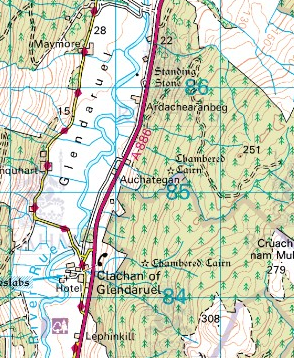
Ordnance Survey. (2002). Sheet 55, Lochgilphead and Loch Awe, Ed. C1. 1:50 000. OS Landranger map. Southampton: Ordnance Survey.
Stuart’s enthusiasm for finding and recording the rock-art, contemporaneous in date with the cairn, was infectious- if we could find it hidden amongst the bracken and under carpets of moss! So on Friday, with Eamon (the new CGDT woodland officer), we set off in the midst of a cloud of midges to find this needle in a haystack. Bingo! Eamon found what looked like a cup and ring marked slab, lying just off the proposed new desire line up to the cairn.
In order to know for sure RTI (reflectance transformation imaging) would be the perfect analytical technique.
“It’s like magic!” (Cathy)
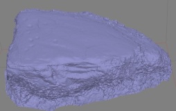
On Sunday we set up what looked like a CSI tent for RTI and this is what we produced!

Stills from the RTI (generated using RTIbuilder, free download available here) of the Lethinkill Rock-Art. Read Left to Right; in each image the light shines on the surface at a different angle. I count 9 cups with key; in both the images on the right there are clearly 2 deliberately carved grooves which make up the ‘key’. What do you see?

The team hard at work at our make-shift RTI tent, in the ColGlen community woodland by Lethinkill!
As Charles writes in his blog, the carvings pop out using this technique. To the naked eye in its natural surroundings, it is very hard to make out any patterns on the slab’s surface (as Cathy’s photogrammetric survey shows).
Everyone in the CGDT group, having never seen this monument before, were thrilled to rediscover a monument which had probably not been seen in over 25 years (since the last archaeological survey was conducted in the area). Cathy has since discovered more references to rock-art in the area, so we hope to see more!

Cathy carrying out a photogrammteric survey of the rock-art by Lethinkill in the ColGlen community woodland.


Photogrammetric model of the Lethinkill rock-art in the ColGlen community woodland, made by Cathy and Mhairi and generated using Agisoft photoscan.
Was it a coincidence all this came to light in on the Solstice weekend?!


